


Rising Fawn, GA
28 miles of trail 2 miles of paved road within the park. We can not reiterate how BEAUTIFUL THIS COURSE IS!!! 4,000 ft of elevation gain for the 50k.
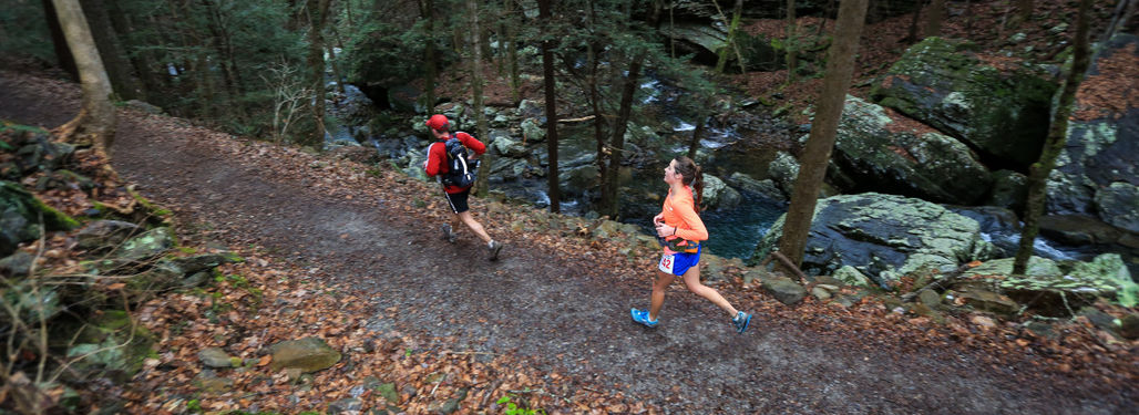
These trails are flat to rolling hills with some short climbs. Nothing over 300 ft at once except the climb out of the canyon at the very end which is 1000 ft in 2.5 miles. These trails are not technical by trail standards but there are some rocks and roots. You will come back to the start and then head out on the last 11 miles of the course will be the hardest/most scenic.
You will run the following trails the last 12 miles: West Rim Trail, Waterfalls Trail, Sitton's Gulch Trail, oh and a fun powerline cut.
So bring your cameras and be ready for a race like no other. Running in and around the canyon will make you forget you're in Georgia.
The West Rim Trail is EXTREMELY rocky and technical. Sittons Gulch Trail is a beautiful path that follows a creek. When you run this you will feel like you are in the Pacific Northwest.
Upcoming Races
Dec 8 2024
50 KM
4,500
ft.
Mixture
Course
4 Aid
Stations
11:00 Cutoff
3
Elevation Rating
Hilly, ~2500-7500 feet in 50 miles
3
Surface Rating
Some rocks, root, and/or ruts
Dec 7 2024
50 Miles
6,500
ft.
Mixture
Course
7 Aid
Stations
15:30 Cutoff
3
Elevation Rating
Hilly, ~2500-7500 feet in 50 miles
3
Surface Rating
Some rocks, root, and/or ruts
Results
50 KM
View course top times| Date | Finishers | Top Result (M) | Top Result (F) |
|---|---|---|---|
| 12/03/23 | 159 | 4:36:39 | 5:30:18 |
| 12/04/22 | 133 | 5:15 | 5:15:06 |
| 12/04/21 | 134 | 5:39:39 | 5:40:04 |
| 12/05/20 | 153 | 5:00:30 | 5:55:36 |
| 12/07/19 | 255 | 3:34:07 | 4:44:25 |
| 02/09/19 | 180 | 3:45:04 | 4:46:18 |
| 02/10/18 | 136 | 4:13:08 | 5:20:54 |
| 01/07/17 | 109 | 4:08:32 | 4:49:11 |
50 Miles
View course top times| Date | Finishers | Top Result (M) | Top Result (F) |
|---|---|---|---|
| 12/02/23 | 105 | 7:37:53 | 8:51:24 |
| 12/03/22 | 88 | 7:33:06 | 8:26:42 |
| 12/04/21 | 88 | 8:59:31 | 9:49:04 |
| 12/05/20 | 80 | 8:59:52 | 8:45:06 |
| 01/09/16 | 112 | 7:50:22 | 9:19:05 |
| 01/10/15 | 75 | 7:34:24 | 9:29:12 |


